 Loading... Please wait...
Popular Brands
Our Newsletter
 New Products
-
 $6,200.00
-
 $5,200.00
-
 $7,000.00
-
 $8,000.00
-
 $7,500.00
- Home
- Mapping GPS Systems
- Trimble R2 Integrated GNSS System

Product Description
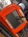
Trimble R2 Integrated GNSS System
The Trimble R2 Integrated GNSS System is a high-accuracy, versatile positioning solution designed for surveying, mapping, and geospatial data collection. Built to deliver submeter to centimeter-level precision, the R2 ensures reliable, consistent results in a wide range of challenging environments.
This compact and rugged GNSS receiver supports multiple satellite constellations, including GPS, GLONASS, Galileo, BeiDou, and QZSS, ensuring maximum satellite coverage and enhanced reliability. The R2 offers real-time correction support, including Trimble RTX™, VRS, SBAS, and RTK, enabling accurate positioning even in remote areas.
Designed for flexibility, the Trimble R2 can be used with a pole, tripod, or mounted on vehicles. It pairs seamlessly with various Trimble controllers and field software, such as Trimble Access™ and Trimble TerraFlex™, enhancing data collection efficiency and accuracy. Its Bluetooth and USB connectivity allow for fast, efficient data transfer and device management.
The IP-65-rated rugged housing provides protection against dust, water, and harsh field conditions, while the removable, rechargeable battery ensures up to 8 hours of continuous operation.
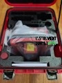
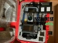
Package Includes (Typical Configuration)
-
Trimble R2 Integrated GNSS Receiver Unit
-
Internal GNSS Antenna (Multi-Constellation Support: GPS, GLONASS, Galileo, BeiDou)
-
Bluetooth and USB Connectivity
-
Rechargeable Lithium-Ion Battery
-
Battery Charger & AC Power Adapter
-
USB Data Cable
-
Pole Mount or Range Pole Clamp Kit
-
Hard Transport/Carrying Case
-
User Manual & Quick Start Guide
-
Calibration Certificate
-
1-Year Warranty & Trimble Technical Support