 Loading... Please wait...
Popular Brands
Our Newsletter
 New Products
-
 $6,200.00
-
 $5,200.00
-
 $7,000.00
-
 $8,000.00
-
 $7,500.00
- Home
- Mapping GPS Systems
- Trimble R8s Integrated GNSS System

Product Description
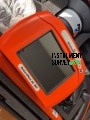
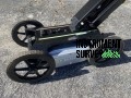
Trimble R8s Integrated GNSS System
The Trimble R8s Integrated GNSS System is a high-performance solution designed to deliver precise, reliable positioning for a variety of surveying and geospatial applications. With its modular and scalable design, the R8s allows professionals to configure the system with the specific features they require, ensuring flexibility and cost-efficiency for any project.
Equipped with Trimble 360 advanced satellite tracking technology, the R8s supports multiple GNSS constellations, including GPS, GLONASS, Galileo, BeiDou, and QZSS. This ensures superior satellite coverage and accuracy, even in challenging environments such as urban canyons and dense forests.
The R8s also features Trimble xFill® technology, which extends RTK coverage during temporary correction signal outages, minimizing downtime and maintaining productivity. Its rugged, IP67-rated housing guarantees reliable operation in harsh environmental conditions, while the lightweight and ergonomic design makes it easy to transport and deploy in the field.
Key Features:
- ? Customizable Configuration – Choose the features and performance levels that meet your specific project needs.
- ? Multi-Constellation GNSS Support – Tracks GPS, GLONASS, Galileo, BeiDou, and QZSS for maximum satellite coverage.
- ? Trimble 360 Technology – Advanced satellite tracking for enhanced accuracy and faster initialization.
- ? Trimble xFill® Technology – Maintains RTK precision during temporary signal outages.
- ? Flexible Operation Modes – Functions as a base station or rover, providing versatility for any survey setup.
- ? Seamless Connectivity – Integrated Bluetooth®, Wi-Fi, USB, and optional 3G modem for flexible data communication.
- ? Rugged Design – IP67-rated housing for protection against water, dust, and harsh environmental conditions.
- ? Extended Battery Life – Long-lasting Lithium-ion battery supporting up to 15 hours of continuous fieldwork.
- ? Lightweight and Portable – Ergonomic design for easy handling and transport.
Applications:
The Trimble R8s Integrated GNSS System is ideal for a wide range of professional applications, including:
- ? Land and Construction Surveying – Conduct precise boundary, topographic, and infrastructure surveys.
- ? Geospatial Data Collection – Capture accurate spatial data for mapping and analysis.
- ? Utility and Infrastructure Mapping – Document and manage critical infrastructure projects.
- ? Agriculture and Environmental Surveys – Enhance resource management with precise field data.
- ? Mining and Resource Management – Optimize extraction and mapping processes.
Specifications:
- Satellite Support: GPS, GLONASS, Galileo, BeiDou, QZSS
- Positioning Accuracy:
- RTK: Up to 1 cm + 1 ppm
- SBAS: Submeter accuracy
- Static Horizontal Accuracy: 3 mm + 0.1 ppm
- Connectivity: Bluetooth®, Wi-Fi, USB, optional 3G modem
- Power Source: Removable Lithium-ion battery
- Battery Life: Up to 15 hours of continuous use
- Environmental Rating: IP67 (dustproof and waterproof)
- Shock Resistance: Survives 2-meter (6.6 feet) drops onto concrete
- Weight: Approx. 1.2 kg (2.65 lbs)
- Operating Temperature: -40°C to +65°C (-40°F to +149°F)
- Dimensions: 19.7 cm x 9.9 cm (7.75 in x 3.9 in)
Included Accessories:
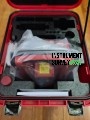
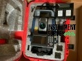
- R8s Accessory – Transport Case (Single or Double Receiver)
- Accessory – Battery – Lead Gel Charging Kit, Outside with Pouch, 6Ah, 0S/7P/M Cable
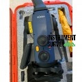
- R8S UHF Rover/Base Receiver
- 2X Receiver Batteries
- Dual Hard Carry Case
- UHF Antenna
- Dual Bay Battery Charger
- Rover Carbon Fiber 2M Rod
- BiPod
- R8/ R8s Li-Ion Rechargeable Battery 7.4V, 2800 mAHr
- R8s- UHF Radio Antenna (Survey)
- Antenna Module Connection Cable Set Replacement for R8s
- TPP Firmware Warranty Good Until 01/06/2023
The Trimble R8s Integrated GNSS System delivers unparalleled flexibility, accuracy, and durability for geospatial professionals. With its scalable design, advanced GNSS tracking, and rugged construction, it ensures reliable and precise data collection for any surveying or mapping project.