Trimble R10 Model 2 GNSS System
The Trimble R10 Model 2 GNSS System is an advanced, high-performance GNSS receiver designed to meet the evolving demands of professional surveying and geospatial data collection. Building on the legacy of the original R10, the Model 2 introduces enhanced features and cutting-edge technology for even greater positioning accuracy, flexibility, and efficiency in the field.
Powered by Trimble ProPoint GNSS technology, the R10 Model 2 delivers superior signal tracking and accuracy in challenging environments, including urban canyons, dense forests, and rugged terrain. The system supports all major GNSS constellations and correction services, ensuring fast, reliable, and consistent results for RTK and post-processed workflows.
The R10 Model 2 also integrates Trimble SurePoint tilt compensation, enabling accurate measurements even when the survey pole isn’t perfectly vertical, enhancing speed and productivity. Additionally, Trimble xFill technology extends RTK positioning during signal outages, ensuring uninterrupted work in the field.
With its compact and lightweight design, advanced connectivity options, and rugged durability, the Trimble R10 Model 2 is engineered for precision, reliability, and ease of use, making it an indispensable tool for surveyors and geospatial professionals.
Package Contents (What’s Included):
A standard Trimble R10 Model 2 GNSS System package typically includes:
-
Trimble R10 Model 2 GNSS Receiver
– Advanced GNSS receiver with Trimble HD-GNSS, xFill, and CenterPoint RTX technology
-
Trimble TSC7 or TSC5 Controller (optional, depending on configuration)
– With Trimble Access software for field data collection
-
2× Rechargeable Lithium-Ion Batteries
-
Dual-Bay Battery Charger with Power Cable
-
Quick Release Adapter / GNSS Antenna Pole Clamp
-
USB Data Cable
-
Rugged Carrying Case (shockproof and foam-lined)
-
User Manual / Quick Start Guide
-
Calibration Certificate
-
Trimble Access Field Software License (if included with controller)
-
SIM Card and Cellular Modem Setup (for RTK corrections, if applicable)
 Loading... Please wait...
 New Products
 $6,200.00
 $5,200.00
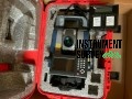 $7,000.00
 $8,000.00
 $7,500.00