Topcon IS-3 Imaging Total Station
The Topcon IS-3 Imaging Total Station is an innovative solution that combines advanced robotic surveying technology with high-resolution imaging capabilities. Designed to enhance productivity and precision in the field, the IS-3 delivers unparalleled accuracy, intuitive control, and real-time visual documentation, making it an essential tool for surveying, construction, and geospatial data collection.
At the heart of the IS-3 is its integrated dual-camera system, providing high-resolution color images and real-time video capture. This allows surveyors to document site conditions, capture evidence, and remotely monitor and control the instrument from a distance. The combination of long-range reflectorless EDM technology and robotic motorized control ensures that measurements are fast, accurate, and efficient—even in challenging environments.
With Topcon’s X-TRAC 8™ technology, the IS-3 guarantees rapid and reliable prism tracking, even in obstructed or complex terrain. Its robust design, paired with IP65 environmental protection, ensures long-lasting performance in harsh conditions, while the intuitive onboard software streamlines workflows for maximum productivity.
Whether for topographic surveying, construction layout, or geospatial documentation, the Topcon IS-3 Imaging Total Station offers superior performance, flexibility, and efficiency.
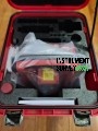
Package Contents (What’s Included):
A typical Topcon IS-3 Imaging Total Station package includes:
-
Topcon IS-3 Total Station Unit
– Robotic imaging total station with advanced scanning, tracking, and imaging capabilities
-
2× Rechargeable Lithium-Ion Batteries
-
Battery Charger with AC Adapter
-
Bluetooth or Long-Range Radio Module (built-in or external)
-
External Controller (e.g., Topcon FC-6000 or FC-5000) with Magnet Field Software (optional)
-
USB Cable or Data Transfer Cable
-
Memory Card / Internal Data Storage
-
Hard Carrying Case (rugged and foam-padded)
-
Tribrach and Adapter
-
Lens Cap / Sunshade and Cleaning Cloth
-
Calibration Certificate
-
User Manual / Quick Start Guide
 Loading... Please wait...
 New Products
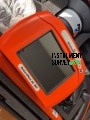 $6,200.00
 $5,200.00
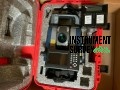 $7,000.00
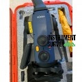 $8,000.00
 $7,500.00