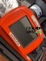
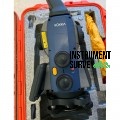
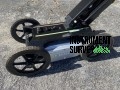
RIEGL VZ-400i 3D Laser Scanner
The RIEGL VZ-400i is a cutting-edge 3D terrestrial laser scanner designed for high-speed, high-accuracy data capture in various surveying and mapping applications. Featuring advanced Waveform-LiDAR technology, it delivers precise, detailed, and reliable 3D data, making it ideal for industries like architecture, civil engineering, mining, forestry, and geospatial surveying.
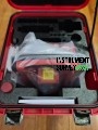
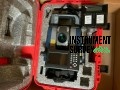
Key Features & Benefits
✅ High-Speed Data Acquisition
- Captures up to 1.2 million measurements per second for rapid and efficient data collection.
- Provides fast, accurate scanning with a range of up to 800 meters for long-distance applications.
✅ Exceptional Accuracy & Resolution
- Delivers millimeter-precision measurements with a range accuracy of ±5 mm.
- Equipped with a high-angular resolution for capturing fine details in complex environments.
✅ Waveform-LiDAR Technology
- Utilizes multi-target capability to capture detailed data from vegetation, powerlines, and urban structures.
- Provides superior performance in challenging environmental conditions, including bright sunlight and dust.
✅ Onboard Data Processing
- Features powerful internal processing capabilities for real-time data quality checks and preliminary analysis.
- Integrated GNSS and IMU sensors for accurate positioning and orientation, ensuring seamless georeferencing.
✅ Advanced Connectivity & Integration
- Multiple interfaces including USB, LAN, WLAN, and mobile connectivity for efficient data transfer.
- Supports integration with external sensors like cameras, thermal sensors, or hyperspectral scanners for multi-sensor applications.
✅ Rugged and Lightweight Design
- Built for demanding fieldwork with a lightweight and robust housing.
- Weather-resistant and operational in extreme environmental conditions (-10°C to +50°C).
✅ User-Friendly Operation
- Intuitive interface with a high-resolution touchscreen display.
- Automated calibration and data acquisition for increased efficiency.
Technical Specifications
- Laser Class: Class 1 (eye-safe)
- Measurement Rate: Up to 1.2 million measurements/second
- Range:
- Up to 800 meters for natural targets (reflectivity ≥ 80%)
- Range Accuracy: ±5 mm
- Field of View:
- Vertical: 100°
- Horizontal: 360°
- Angular Resolution: 0.0005°
- Integrated Sensors: GNSS, IMU, compass, and barometer
- Data Storage: Integrated SSD with additional external storage options
- Connectivity: USB, LAN, WLAN, LTE, and Bluetooth
Applications
???? Architecture & Construction: Detailed 3D scans for BIM modeling and structural analysis.
???? Civil Engineering: Captures terrain and infrastructure data for road, bridge, and tunnel surveys.
???? Forestry: Measures vegetation structure and canopy layers for environmental analysis.
???? Mining & Geology: Accurate volumetric analysis and terrain mapping for resource management.
???? Urban Planning & Heritage: Captures detailed 3D data for city modeling and heritage conservation.
The RIEGL VZ-400i stands out as an advanced, versatile, and reliable 3D laser scanning solution, offering high-speed data acquisition, exceptional accuracy, and robust field performance. Whether for complex industrial surveys or large-scale environmental mapping, it ensures efficient workflows and precise results.