Topcon HiPer HR GNSS Receiver
The Topcon HiPer HR GNSS Receiver is a state-of-the-art, high-performance solution designed for superior positioning accuracy and reliability in the most demanding field environments. Engineered with Topcon's patented Universal Tracking Technology and TILT™ compensation, the HiPer HR is built to deliver precision, flexibility, and ease of use for all types of GNSS applications.
This compact and robust receiver supports all current and future GNSS constellations, including GPS, GLONASS, Galileo, BeiDou, and QZSS. The HiPer HR integrates seamlessly into various field workflows, supporting RTK, network RTK, and static data collection. The advanced TILT™ technology allows for accurate point measurements without the need to level the pole, increasing speed and efficiency in the field.
With Integrated 4G LTE, Wi-Fi, Bluetooth®, and UHF communication options, the HiPer HR ensures robust, real-time connectivity for smooth and efficient data transfer. The Topnet Live service enables hassle-free, network-based corrections, enhancing accuracy and productivity.
Designed for versatility and durability, the HiPer HR features an IP67-rated enclosure, ensuring resistance to water, dust, and harsh environmental conditions. Whether for construction layout, topographic surveying, or GIS data collection, the Topcon HiPer HR is engineered to exceed expectations and maximize field productivity.
Package Includes (Typical Configuration)
-
Topcon HiPer HR GNSS Receiver Unit
-
Internal UHF Radio / Cellular Modem (depending on configuration)
-
Built-in Tilt Compensation Sensors (IMU)
-
Internal Rechargeable Lithium-Ion Battery
-
Battery Charger & Power Adapter
-
USB Cable / Data Transfer Cable
-
Antenna Calibration Certificate
-
Hard Carrying Case (Rugged Design)
-
User Manual / Quick Start Guide
-
TopNET+ or MAGNET Field Compatible (license optional)
-
1-Year Standard Warranty & Technical Support
 Loading... Please wait...
 New Products
 $6,200.00
 $5,200.00
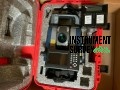 $7,000.00
 $8,000.00
 $7,500.00