 Loading... Please wait...
Popular Brands
Our Newsletter
 New Products
-
 $6,200.00
-
 $5,200.00
-
 $7,000.00
-
 $8,000.00
-
 $7,500.00
- Home
- Robotic Total Station
- Topcon GT-1002 Robotic Total Station
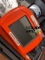
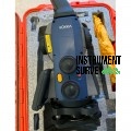
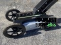
Topcon GT-1002 Robotic Total Station

Product Description
Topcon GT-1002 Robotic Total Station
The Topcon GT-1002 Robotic Total Station is a high-precision, ultra-compact surveying instrument designed for construction, land surveying, and infrastructure development. Built with advanced robotic technology, superior angle accuracy, and durable construction, the GT-1002 enhances productivity and ensures reliable, high-accuracy measurements in any field condition.
Advanced Robotic Technology for Single-Operator Efficiency
The GT-1002 is equipped with ultra-fast robotic motors and UltraTrac prism tracking technology, ensuring rapid and precise target acquisition. This allows for single-operator control, significantly increasing productivity while reducing manpower. The instrument maintains stable and consistent tracking even in challenging environments with obstructions or over long distances.
High-Precision Measurements with Extended Range
Delivering 2-second angle accuracy, the GT-1002 ensures precise layout and measurement in any application. Its long-range EDM system measures distances up to 5,000 meters with a prism and 800 meters in reflectorless mode, providing versatility for diverse surveying tasks.
Rugged and Lightweight Design for Field Durability
Built to withstand the rigors of the field, the GT-1002 is IP65-rated for protection against dust and water. It is engineered to handle extreme temperatures and rough conditions, ensuring consistent performance in harsh environments. Despite its ruggedness, the GT-1002 maintains a compact, lightweight design for easy transport and setup.
Seamless Connectivity and Software Integration
The GT-1002 supports Bluetooth and LongLink connectivity, allowing for remote control and seamless data transfer. It is fully compatible with Topcon’s MAGNET software suite, enabling efficient data collection, real-time collaboration, and streamlined field-to-office workflows.
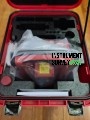
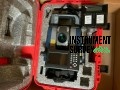
Package Contents (What’s Included):
A standard Topcon GT-1002 Robotic Total Station package typically includes:
-
Topcon GT-1002 Total Station Unit
– High-speed robotic total station with 2-second angular accuracy and ultrasonic motor technology -
2× Rechargeable Lithium-Ion Batteries
-
Battery Charger with AC Power Adapter
-
RC-5A Remote Control Unit or Optional Data Collector (e.g., FC-6000 with MAGNET Field Software)
-
Tribrach with Optical Plummet
-
USB or Bluetooth Communication Cable
-
SD Card or Internal Memory
-
Rugged Carrying Case (foam-padded and weather-resistant)
-
Sunshade, Lens Cap, and Cleaning Cloth
-
Calibration Certificate
-
Quick Start Guide / User Manual