FARO Focus S350 Laser Scanner
The FARO Focus S350 Laser Scanner is a high-precision, long-range 3D scanning solution designed for professionals in construction, surveying, forensics, industrial plant documentation, and heritage preservation. With a maximum scanning range of 350 meters (1,148 feet), it delivers unmatched accuracy, speed, and reliability in both indoor and outdoor environments.
Built for rugged field conditions, the IP54-rated Focus S350 is dust- and water-resistant, ensuring reliable operation in challenging environments. The scanner features advanced HDR imaging, allowing for high-resolution, colorized point clouds even in low-light or high-contrast conditions. Its dual-axis compensator, GPS integration, and real-time cloud connectivity make it an ideal tool for geospatial professionals.
With Wi-Fi and Bluetooth connectivity, along with compatibility with industry-leading software like FARO SCENE, Autodesk ReCap, Bentley MicroStation, and more, the Focus S350 ensures a seamless workflow from field to final deliverables.
For professionals requiring long-range, high-accuracy 3D scanning with industry-leading technology, the FARO Focus S350 is the ultimate solution.
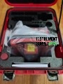
Package Includes (Typical Configuration)
-
FARO Focus S350 Laser Scanner Unit
-
2x Lithium-ion Rechargeable Batteries
-
Battery Charging Station & Power Supply
-
16GB / 32GB SD Card (Depending on configuration)
-
SD Card Reader
-
FARO Transport & Carrying Case (Rugged Hard Case)
-
FARO SCENE Software License (Optional/Trial)
-
Tripod Adapter
-
Quick Start Guide / User Manual
-
Calibration Certificate
-
Protective Cover / Sun Shield
-
WIFI & GPS Module (Integrated)
-
Compass & Altimeter (Built-in)
-
Standard Warranty and Technical Support
 Loading... Please wait...
 New Products
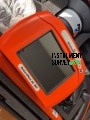 $6,200.00
 $5,200.00
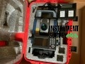 $7,000.00
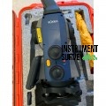 $8,000.00
 $7,500.00