FARO Focus3D X330 Laser Scanner
The FARO Focus3D X330 Laser Scanner is a high-performance, long-range 3D laser scanner designed for precise and detailed scanning of large environments. With an extended scanning range of up to 330 meters (1,082 feet), it is ideal for applications such as architecture, engineering, construction, forensics, surveying, and industrial plant documentation.
Equipped with advanced laser technology, the Focus3D X330 captures millions of data points per second with exceptional accuracy, even in challenging lighting conditions and over long distances. The scanner features integrated GPS, allowing seamless alignment of multiple scans in large-scale projects. Its compact, lightweight, and rugged design makes it easy to transport and operate, whether on-site or in remote locations.
The FARO Focus3D X330 is designed to deliver fast, efficient, and high-resolution 3D point cloud data, reducing time and costs in data collection and post-processing. Its powerful HDR imaging capabilities and enhanced noise reduction technology ensure clear, accurate, and high-quality scan results, even in bright sunlight or low-reflectivity surfaces.
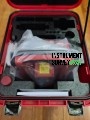
Package Includes (Typical Configuration)
-
FARO Focus3D X330 Laser Scanner Unit
-
2x Lithium-Ion Rechargeable Batteries
-
Battery Charger & Power Adapter
-
FARO SCENE Software (license may be included or optional)
-
Industrial-Grade Transport Case
-
SD Card or Internal Storage for Data Logging
-
Tripod (optional or bundled)
-
USB Cable & Data Transfer Accessories
-
Quick Start Guide / User Manual
-
Calibration Certificate
-
1-Year Standard Warranty & Software Support
-
Optional Add-ons: GPS integration, targets, remote controls, additional software modules
 Loading... Please wait...
 New Products
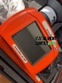 $6,200.00
 $5,200.00
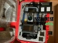 $7,000.00
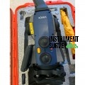 $8,000.00
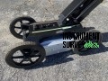 $7,500.00