Topcon HiPer VR GNSS Receiver
The Topcon HiPer VR GNSS Receiver represents the next generation of high-precision GNSS technology, designed to meet the rigorous demands of modern surveying and geospatial applications. Built with Topcon's Universal Tracking Technology™, it ensures unparalleled performance by supporting all current and planned global satellite constellations, including GPS, GLONASS, Galileo, BeiDou, and QZSS.
This receiver features Vanguard Technology for superior signal acquisition and retention, ensuring faster fixes and higher accuracy even in challenging environments such as urban canyons and dense forests. Its TILT™ technology enables accurate measurements without the need for perfect leveling, making fieldwork faster and more efficient.
The HiPer VR is designed for ultimate flexibility, supporting cellular, LongLink™, and UHF radio communications for seamless base-rover operations and real-time corrections. With its compact, cable-free design and robust IP67-rated build, the HiPer VR is built to withstand tough environmental conditions, ensuring reliable performance in any field scenario.
Integrated with advanced data logging and storage capabilities, this receiver is optimized for both static and dynamic data collection, making it ideal for diverse applications, from topographic surveying to construction site layout and geospatial mapping.
Key Features of the Topcon HiPer VR GNSS Receiver:
? Universal Satellite Tracking – Supports GPS, GLONASS, Galileo, BeiDou, and QZSS for superior global coverage.
? Vanguard Technology – Ensures faster satellite acquisition, enhanced signal retention, and high-accuracy positioning.
? TILT™ Technology – Allows for accurate point measurement without perfectly leveling the receiver.
? Integrated Communication Options – Includes Bluetooth®, Wi-Fi, LongLink™, UHF radio, and cellular connectivity for versatile data transfer and communication.
? Robust Design – IP67-rated for dust and water resistance, withstanding harsh field conditions.
? Cable-Free and Lightweight – Simplifies transport and setup, enhancing field efficiency.
? Long Battery Life – Provides up to 12 hours of continuous operation for extended fieldwork.
Applications:
- Land Surveying – Accurate data collection for boundary and topographic surveys.
- Construction Layout – Ensures precise site layout and infrastructure planning.
- Geospatial Mapping – Ideal for large-scale mapping and GIS applications.
- Agricultural Surveys – Supports precision agriculture through accurate land measurements.
- Environmental Studies – Reliable for environmental monitoring and resource management projects.
Why Choose the Topcon HiPer VR GNSS Receiver?
The Topcon HiPer VR is engineered for surveyors and geospatial professionals who demand accuracy, reliability, and flexibility. Its advanced multi-constellation tracking and tilt compensation technology enable faster and more efficient fieldwork, even in challenging environments.
The receiver's integrated communication systems provide flexible options for real-time data transfer and corrections, ensuring optimal operational efficiency. The rugged, compact design is built to withstand the harshest conditions, offering durability without compromising performance.
Whether you're working in urban areas, forests, or open landscapes, the HiPer VR guarantees consistent, high-accuracy results, reducing downtime and increasing productivity.
 Loading... Please wait...
 New Products
 $6,200.00
 $5,200.00
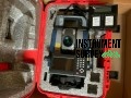 $7,000.00
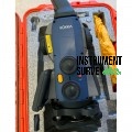 $8,000.00
 $7,500.00