Topcon HiPer SR GNSS Receiver
The Topcon HiPer SR GNSS Receiver is a lightweight, compact, and highly reliable solution designed to deliver precision and versatility for a wide range of surveying and construction applications. Powered by Topcon's advanced GNSS technology and integrated LongLink™ Bluetooth® communication, the HiPer SR ensures fast, accurate positioning and effortless field operations.
This receiver supports multi-constellation tracking, including GPS, GLONASS, Galileo, and BeiDou, providing consistent performance even in challenging environments. Whether used for RTK base and rover setups or as part of a network rover configuration, the HiPer SR offers flexibility and scalability to meet diverse project needs.
The HiPer SR is engineered for simplicity and durability. Its IP67-certified enclosure ensures resistance to water, dust, and shocks, making it ideal for harsh field conditions. Its compact and cable-free design reduces setup time and enhances portability, while the integrated LongLink™ communication technology offers reliable, long-range connectivity of up to 300 meters (984 feet) between base and rover units.
Additionally, the HiPer SR features internal batteries for extended field operation and supports seamless integration with Topcon Magnet™ Field software, ensuring efficient data collection and processing.
Package Includes (Typical Configuration)
-
Topcon HiPer SR GNSS Receiver Unit
-
Internal UHF or Long-Range Bluetooth Radio
-
Integrated Antenna (All-in-One Design)
-
Rechargeable Lithium-Ion Battery
-
Battery Charger & AC Power Adapter
-
USB Cable / Data Transfer Cable
-
Hard Carrying/Transport Case
-
User Manual & Quick Start Guide
-
Antenna Calibration Certificate
-
1-Year Manufacturer Warranty & Technical Support
 Loading... Please wait...
 New Products
 $6,200.00
 $5,200.00
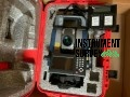 $7,000.00
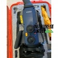 $8,000.00
 $7,500.00