 Loading... Please wait...
Popular Brands
Our Newsletter
 New Products
-
 $6,200.00
-
 $5,200.00
-
 $7,000.00
-
 $8,000.00
-
 $7,500.00
- Home
- GNSS System
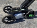
- Leica GS18 I GNSS RTK Rover Package

Product Description
Leica GS18 I GNSS RTK Rover Package
The Leica GS18 I GNSS RTK Rover Package is an industry-leading solution designed to revolutionize surveying with advanced visual positioning technology. It combines GNSS, IMU, and camera technology, allowing surveyors to capture high-precision measurements from images. This capability simplifies data collection in challenging or obstructed environments, enhancing efficiency and reducing time spent in the field.
With real-time kinematic (RTK) technology, the GS18 I delivers centimeter-level accuracy, ensuring reliable results for a wide range of applications. The innovative Visual Positioning system allows users to measure points from images, eliminating the need for direct line-of-sight or physical access to every point. Its integrated IMU sensor ensures fast, tilt-compensated measurements without the need to level the pole manually.
The GS18 I is ruggedly built for harsh conditions, with an IP68 rating for dust and water resistance. Combined with the Leica Captivate software and compatibility with various field controllers, it offers a seamless and intuitive user experience.
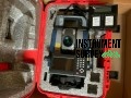
Package Contents (What’s Included):
A standard Leica GS18 I GNSS RTK Rover Package typically includes:
-
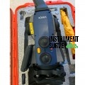
Leica GS18 I GNSS Smart Antenna (Imaging GNSS Rover)
– With visual positioning technology for capturing and measuring points from images -
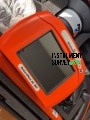
Leica CS20 or CS35 Field Controller with Leica Captivate Software
– For real-time data collection, 3D visualization, and image measurement -
Camera-enabled GNSS Receiver with Inertial Measurement Unit (IMU)
-
2× Rechargeable Lithium-Ion Batteries
-
Battery Charger with Power Cable
-
Carbon Fiber Rover Pole with Smartphone Mount
-
USB Data Cable / Bluetooth / Wi-Fi Connectivity
-
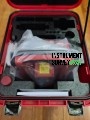
Rugged Carrying Case (shockproof and weather-sealed)
-
User Manual / Quick Start Guide
-
Leica Captivate Software License (with Imaging Module)
-
Calibration Certificate and Registration Documents